THE DYNAMIC EARTH: A BLOG ABOUT GEOLOGY AND THE EARTH SCIENCES

Sunday, April 20, 2008

Expelled Exposed

Just a quick break from the Death Valley posting (calm down, calm down; the alluvial fans will be posted soon; you people are insatiable!).

As many of you know, ol' Ben Stein (the man who, single-handedly, tried to save us all from red, scratchy eyes) has recently come out with a piece of creationist filth called "Exposed".  Apparently, one of the highlights of the film is a ponderously paced explanation about how people who accept evolution (you know, smart people) are worse than Nazis.  Apparently people were only ever killed in an organized, large-scale fashion AFTER 1859; who knew?

Anyway, Eugenie Scott, of the National Center of Science Education and a tireless warrior for Reason, has spearheaded the creation of a website debunked all the IDiotic bullshit promulgated by the film.  I have linked to their site "Expelled Exposed" under my Earth Science Resources list in the margin, but I'll also drop it in right here:

http://www.expelledexposed.com/

I would strongly suggest we weary blogonauts ALL link to this website.  I'm just a simply, country field geologist,but I think that the way the internets works is that, if we all link something, its position in the Google hierarchy goes up, which might result in the debunking site coming up first in a google search for the movie.  Which would be rad, by the way.

Tuesday, April 15, 2008

Death Valley Evaporites

I realized, looking through my pictures, that I had a bunch of thematically similar pictures from a scattering of day; specifically, a bunch of playa lake pictures (evaporative lakes are a favorite topic of one of the profs on the trip) and a bunch of alluvial fans (a favorite of mine). So, I thought I’d just glom them all into individual posts. An alluvial fan post will be coming up soon, so today I submit pictures of playas for your viewing pleasure.

Playa lakes are bodies of water that are intermittently wet, often shallow, and commonly sites of evaporite deposition, due to the high evaporation/precipitation ratio.

As I typed that sentence above, I had a great idea for a t-shirt or bumper sticker: “Don’t hate the playa, hate the evaporation/precipitation regime”. It’s so pure, I might just cry.

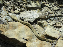
Anyway, Death Valley and its neighboring valleys are hot and dry, so it’s a good place to go playa spotting. The famous playa in Death Valley proper is that Badwater playa, which is filthy with tourists. If you are looking for a more picturesque spot away from the crowds, I would suggest heading west toward the Panamint valley, and wandering along the road heading south of Ballarat towards all the BLM land. The picture below shows one of these evaporative lakes:


Walking out onto the playa, you can come across some really slick evaporative minerals; note the round little balls and the whispy, thread-like crystals in the picture below (snagged from another of my fellow field-trippers, with the very edge of a camera lens cover for scale). There was a major component of halite in this lake setting (it tasted like salt).


The growth of these evaporites under intermittent conditions leads to the development of large scale shrink-swell features, such as seen in the picture below (with someone’s great tromping footprints for scale). Evaporites can be seen filling in the cracks.


The action of waves and moving water is still important in these shallow lakes. In the picture below, symmetrical wave-ripples that parallel the shoreline (which is off-camera) can be seen, already encrusted with evaporites. These speak to periods of time when the water level in the lake was higher; this rapid and often dramatic fluctuation of lake level is an important characteristic of modern playa lakes. The stratigraphic implications of these geomorphic systems can be a little off-putting; what is a Waltherian succession within lacustrine strata?


Water conduits (and even a few channels) were obvious along the lake margins; these areas were muddy, devoid of plants, and often had little evaporite deposition within them.
The picture below shows some interesting bedform features indicative of fairly vigorous flow conditions. I interpreted these as being muddy parting lineations, with some subordinate mud-rip up features and mud-ball formation. Given time and compaction, a resultant mudrock succession would look fairly uniform and rather boring, leading us to erroneously assume fall-out suspension as the primary depositional feature of fine-grained sediment in this setting.


Next time: Modern Alluvial Fans

Friday, April 11, 2008

Death Valley Day 5: Lost Burro Section

A major component of the geology in the west is made up of the Paleozoic miogeocline; this wedge of sediment thickened seaward, and represents the tectonically quiescent passive margin of the western edge of the continent. There are some phenomenal sections in Death Valley that expose portions of this wedge, and one of the profs leading the trip has a sweet-tooth for Paleozoic miogeoclinal strata; as such, our fifth day in Death Valley was spent wandering through the Devonian Lost Burro Fm, near the Lost Burro Mine. The mine is up fairly high (3000+ meters, or so), and has that classic western geology look to it, all scrubby vegetation and outcrop.


This section has been interpreted as a large carbonate ramp, and is chock full of stromatoporoid sponge mounds (such as in the picture below). These sponges were the dominant reef-building critters in the Devonian.


There were also some sections dominated by fragments of a wispy, thin-walled Amphipora, which is also a stromatoporoid (thanks Shanan!) that must have been getting beat-up and sloshed around before its final deposition (below):


Thankfully, there were SOME bedforms to be seen in amongst the carbonates; the picture below shows some calciclactic (ooidal) HCS and SCS; this high energy lithofacies always capped off the shallowing-upward cycles (parasequences) preserved in this overall shallowing upward succession.


Further up the canyon, we were able to follow these carbonates all the way up to a pretty slick surface. The picture below shows a fairly important transition in the geological history of the world; the tan-orange stuff to the right in all shore-face sands (trough and planar x-beds, HCS and SCS, ripples, and shelly detritus), whereas the darker stuff to the left is all siliciclastic mud interbedded with thin carbonates.


It is pretty clearly a flooding surface, putting deeper-water units overtop of shallower, coarser units. But what is really nifty is the paleo story preserved here. Below that contact, there were stromatoporoid reefs; above that contact, there are only crinoids. Turns out, this is the Frasnian-Fammenian boundary, the smallest of the “big-5” extinction events. The stromatoporoids (and trilobites) got whacked pretty hard during this "event", and were replaced by the more familiar post-Devonian faunas and reefs (such as crinoid-reefs).

Saturday, April 5, 2008

Death Valley Day 4: Ubehebe Crater and Race Track Playa

Heading towards exposures of the Devonian and Ordovician in the north end of the park, we stopped off at some of the more tourist-y stops in Death Valley, including Ubehebe Crater and Race Track Playa. There were a fair amount of gawkers, of course, but the geology was pretty slick nonetheless.

Ubehebe crater is part of a chain of 13-16 craters recording Holocene (~6000 years, I think) phreatic volcanism in the region. In addition to the craters proper, base surge deposits can be found in relatively close proximity to the craters, and preserve some phenomenal flow structures.

The picture below was taken from a lookout along the rim of the crater, and shows the fine-grained lacustrine and coarser conglomerate deposits through which the volcano punched. The darker, banded unit that forms the rim proper (and shows an angular discordance with the underlying sediment) are tuffaceous beds with lots of pumice and basalt shards.

To the south of the main crater is Little Hebe, shown in the picture below. It is one of the younger craters, and shows evidence for effusive basalt flows (the rim of this crater is basalt, rather than the base surge deposits seen in the main crater).

If you head south of little hebe, off the beaten path, you will come across some phenomenal sedimentary structures, formed by the high concentration surge deposits as they flowed away from volcano. The picture below shows antidune cross-stratification, a fairly rare sedimentary structure produced by upper flow regime conditions and rapid deposition.

After Ubehebe, we sped northwards towards Racetrack Playa, probably one of the more famous spots in the park. Playa lakes, of course, are known for being FLAT ephemeral ponds, and are often evaporitic in nature; what is unique about Racetrack Playa, however, is that it is not a terminal playa. Rather than being found at the low point in the valley, Racetrack is actually 3000+ meters up in the mountains. There are no evaporite minerals (or casts) to be found in this playa; just a lot of (potentially thixotropic) mud and silt.

That, and the famous moving rocks.

There is still some debate as to what process exactly is responsible for moving these stones. Wind is a favorite explanation, but I would point out that if you look at the picture below, you’ll see a preferred orientation for many of the tracks, as well as a marked similarity in the angle of the changes in their direction. Also, the vast majority of these rocks are sourced from a north-facing prominence of basement rock exposed on the edge of the playa. Given the north-oriented face, 3000+ meter elevation, and the uniform nature of the tracks seen on the edge, we wondered if ice might not play an important role in the entrainment of these blocks.

Coming up next…more Paleozoic Carbonates!

Friday, April 4, 2008

Death Valley Day 3: The Break-up of Rodinia

The Neoproterozoic section in and around Death Valley is metamorphosed to the point of being almost occult; there are tantalizing little glimpses of original fabric and textures, and diligent searching can turn up some sedimentary structures here and there, but by and large, the whole thing can be fairly frustrating. I can only imagine that it would take a fair bit of time to get your eyeballs trained to these old, busted-up rocks, and a fair bit of confidence and imagination to get anything out of them.

Regardless, these rocks preserve a record of the break-up of the supercontinent Rodinia, an event which was at least as enigmatic as the break-up of The Pixies in 1993. As if that isn’t enough for you, some workers have found evidence for the ol “Snowball Earth” hypothesis in these units (in the form of diamictite and cap-carbonates).

We spent all day wandering through the impressively beautiful Goler Wash, near the ghost town of Ballarat in the Panamint Valley, outside of the park. The picture below really doesn’t do it justice. This area is somewhat famous (amongst the geological cognoscenti only, I suspect) for having a fairly completes section of the Kingston Peak Fm and its defined members.

The Kingston Peak Fm rests on gneissic basement, and has a basal breccia dominated by angular gneissic, granitic, and quartzite clasts (see below for a picture). Interestingly, some interpretations suggest that this is a weathering horizon, implying a substantial amount of time preserved on that surface.

Above the basal breccia, coarse siliclastics, some limestones, and conglomerate facies make up the Limekiln Spring and Surprise Members of the Fm. Apparently, mapping at a more regional scale shows that the Limekiln and Surprise Mbrs show evidence for syndepositional extension associated with the initiation of rifting and break-up of Rodinia.

Of particular interest is the Wildrose Diamictite, which unconformably overlies the lower members of the Kingston Peak Fm (see below). The dark-colored diamictite is overlain by the Noonday Dolomite, and together, forms the typical “glaciated to cap-carbonate system” that have been interpreted to show evidence for Snowball Earth.

On an aside, I think the term diamictite has been brutally abused for many years, and it really is time for someone to call Nomenclatural Protective Services. It seems that it is often used as a short-hand for “glacially-derived conglomerates”, and more specifically as a short-hand for “glacial dropstone-cgl”. Diamictites are just poorly sorted conglomerates with a wide range of grain-sizes, 25% of which are gravel-sized or coarser. That’s it! No genetic connotation what-so-ever!

Still, these diamictites have been interpreted as glacial-drop stones. Frankly, I don’t think these rocks show any evidence for that interpretation in outcrop (see below for yourself). To my mind, the evidence needed to convincingly demonstrate a dropstone origin requires disrupted bedding (when the rock drops into the substrate) and evidence for syndepositional thinning and draping of overlying sediment. Otherwise, who’s to say that this isn’t a hyperconcentrated flow, or a debris flow, or something similar. In the papers I’ve read, there has not yet been any particularly convincing evidence for a drop-stone origin, in my humble opinion.

Anyway, overlying the diamictite is a thick dolomite unit; similar strata relationships have been observed is less metamorphosed rocks elsewhere, and on the basis of these better preserved units, these have been interpreted as cap-carbonates. In this interpretation, the world-girdling glaciers that cut off the surface of the oceans from the atmosphere must have severely disrupted the CO2 cycle. This would have resulted in a build-up of atmospheric CO2, which would eventually overwhelm the ice albedo, and initiate melting. The sudden input of all the atmospheric CO2 would result in sudden, rapid precipitation of carbonate in the oceans, including some carbonate textures from other capping intervals that have been interpreted as meter-scale authigenic calcite and aragonite fans precipitated on the seafloor. Pretty wiggy stuff, but we didn’t see any of that in Goler Wash, due to its fairly cooked nature.

Anyway, should you find yourself in the vicinity of Ballarat in the Panamint Valley, drop on by Goler Wash; it is a pretty neat section to walk through, though at the end of the day, you might just decide that you are glad you don’t have to work on those rocks (and if you do have to work on those rocks, allow me to offer my sincerest condolences).

Wednesday, April 2, 2008

Death Valley Day 2.5 – The Tufa Pinnacles near Trona, CA

Near the exceptionally dilapidated town of Trona, CA, are numerous tufa pinnacles, some close to a hundred feet high (or more), that were deposited in an enormous Plio-Pleistocene lake. This paleolake filled the entire valley, and created wave-cut terraces that indicate a maximum depth of around 300 meters or so.

In map view, the tufa pinnacles are distributed along old faults, where fluids enriched in calcium were welling up from the depths; upon debauching into the lake, tufa precipitated out (potentially with the help of microbes). There are a LOT of these pinnacles distributed through this basin (see the picture below for a partial landscape shot I took), indicating a LOT of calcium coming from these fracture networks.

There are some really weird textures preserved in some of these pinnacles; I get the feeling that figuring these things out would require a fairly crazy carbonate worker willing to devote a good chunk of their life. Interestingly, there are several surfaces preserved on various pinnacles at various heights. What do these surfaces mean? Are they regional, and could they represent…SEQUENCE BOUNDARIES (cue dramatic music)!!!!

As with all precipitates (and much of geology), these things can have an embarrassingly phallic appearance.
Since this is all on BLM land, we decided to camp right there. My friend with the billion-dollar camera took some pretty awesome evening and night-time shots of these features. Under a nearly full moon, these things looked pretty ghostly, lemme tell you!

Coming up next…the BREAK-UP OF RODINIA!!!!

Tuesday, April 1, 2008

Death Valley Day 2.0 – Furnace Creek Fm

The Miocene-Pliocene Furnace Creek Formation consists of fluvial and alluvial fan conglomerates, graded sandy turbidites (dominantly T a-b divisions) deposited in a lake, and finer grained lacustrine deposits. It is exposed in several really nice spots in Death Valley, though by far the best exposures are found at the Hole-in-the-Wall campground. The campground is out of the way; you have to drive up a dry river channel to get to it, and it abuts a wilderness area. In my opinion, it is the best campground in the park, for the simple reason that it has incredible exposures of the Furnace Creek Fm.

All the way in the back, near the wilderness area, there is an amazing exposure of conglomerates (the unique weathering pattern is what gives this campground its name of hole in the wall). We camped in Hole in the Wall, and started our second day looking at these strata.

The lowermost clast-supported cgl show evidence of imbrication, are normally graded to ungraded, and interfinger with sandstones showing trough x-stratification, some ripple formsets (on bedding surfaces), and laminated mudrock. As you move up-section, the cgl beds get thicker, and become matrix-supported. Inverse grading becomes dominant, and the clasts are more angular. They really show classic evidence for debris flow processes. To me, it seemed that these active debris flow lobes were part of an alluvial fan complex that adjoined a lake basin.

The picture below shows one of these individual debris flow beds (a single depositional event) THINNING OUT as you move from the left to the right (the kink in the bed is structural deformation related to uplift). How cool is that! You can see the evidence for the flow thinning and freezing!

The picture below is a close up of the distal toe of the above bed; note the inverse grading and presence of outsized, floating clasts at the top of the bed (younging is to the right).

Heading down the road a bit, we encountered the more distal lacustrine beds of the Furnace Creek Fm. The lake environments are dominated by sand-rich turbidites (and maybe a hyperpycnite, here or there; there was some evidence of inverse-to-normal grading within individual beds), massive mudrock (deposited from turbidite plumes?) and laminated claystone (suspension fall-out). I wonder what the relationship of these turbidites is to the debris flows on the adjacent alluvial fan? Could these be sourced by debris flows hitting the lake, entraining water, and transforming into turbulently supported flows? Alternatively, maybe they represent winnowing and reworking of the fan surface during subsequent sheet-flood events, and are only entraining the sands? I reckon detailed petrography and mapping would be the only way to start wrestling with that question.

The picture below is a set of three of these graded beds.

This next picture (below) shows some nice soft-sed deformation (ball and pillow structures, some flame structures) developed where the sand was rapidly deposited on the mud.

Finally, here is a picture of some mud rip-ups in one of these turbidites.
There were many tens of meters of beds just like this; the ol' Furnace Creek Lake must have been getting hit pretty hard with these flows. Interestingly, there is no evidence for evaporite deposition at this location (i.e., displasive crystals, evaporite mineral casts), whereas at other points in the basin, these same lakes do show evaporative evidence.

Well, that does it for the morning of the second day; later, I’ll post some pictures of tufa pinnacles.