I just wanted to quickly point out a really excellent essay that does a killer job deconstructing and exploring the (sometimes stealthy) role that "privilege" has in creating disparities between folks. The essay, titled "Sacrificing Privilege" and hosted at Skepchick, is a clear and well-written exploration of how a "privileged" status, defined on the basis of race, gender, or what-have-you, can serve as the basis of a pervasive and potentially "invisible" culture of bias.
This is an extremely important message that we in the sciences (and especially the Earth Sciences) NEED to understand if we ever want to get away from the "(White) Boys' Club" that defines so many fields. As discussed here in a previous post, Geology has a real problem with regards to gender; understanding and working to eliminate the (often hidden) cultural biases that make it hard for women and minorities to find a home in the sciences is the only way that we'll ever get better. So everyone read the essay linked above! It's long, but well worth the time!
Monday, December 12, 2011
Tuesday, December 6, 2011
Evaporite Casts in Sandstone
I've been working, as part of the ol' PhD rigamarole, in the Wilkins Peak Member, which is part of the Eocene Green River Formation in southwest Wyoming. Anyway, this part of the world during the Eocene was characterized by extremely high evaporation coupled with relatively low precipitation, which is a perfect setting for the formation of evaporites! High evaporation rates drive off water, while leaving behind water soluable ions, resulting over time in highly concentrated brines from which evaporite minerals form.
In previous posts, I've shown some modern examples of evaporite formation from Death Valley, where evaporites are precipitating on a playa surface, which is a pretty good analogue for parts of the Wilkins Peak. This previous post actually shows some evaporite mineral casts from the purely lacustrine portion of the Wilkins Peak, probably some sort of Na-rich evaporite.
However, you don't have to be in the lake for evaporites to form! These pictures below are evaporite mineral casts preserved in sandstones that formed as part of the floodplain/overbank setting of a fluvial system that fed into the lake.

Here's a closer view, showing the bladed, fairly delicate looking crystalline features of the evaporites, preserved in the sands.

I reckon these are Nahcolite casts, on account of their elongated crystal habit, but then again I'm no evaporite specialist. Still, they're kind of nifty!
Friday, December 2, 2011
Ophiomorpha in core
Trace fossils are, as I've said before, pretty rad. As a sed/strat type, I mostly appreciate them for their utility in paleoenvironmental reconstructions, their ability to help us constrain substrate conditions, and the help they can give us in interrogating rates and processes of sedimentation. And, of course, there's all sorts of biological and ecological info to be gleaned from the paleoichnological record as well.
Trace fossils are particularly valuable when all you've got is 3 inch-wide cores to work with! I'm mostly a field guy, but sadly, some strata remain inaccessibly trapped below the surface of the earth, removed from the joyous and perfect cycle of erosion and redeposition that is the true destiny of all rocks everywhere. When we want to investigate these strata, we're forced to yank a plug of rock out of a well somewhere, and just hope for the best. It's not ideal, but you gotta work with what you've got...
Anyway, below are a few pictures of some Ophiomorpha traces I found in core from the Paleocene-Eocene Wilcox fluvial/alluvial/deltaic sediments of the Gulf Coast. Ophiomorpha is such a neat little trace fossil; a little shrimpy bastard digs his way into some shifting sediment, and in order to keep his little dwelling tunnel safe from collapse, he rolls his own shit into little balls, and sticks it into the walls of the burrow. Ah, The Grandeur of Nature at Work!

In the picture above, we've got a pretty nice cross-section in a massive, medium-grained sandstone. You can see pretty clearly the nice fecal ball lining surrounding the inner (and, in the animal's lifetime, what would have been hollow) chamber.

Here's a cut along the length of an Ophiomorpha, truncated by an erosion surface and subsequent plow-and-fill sediment, which was itself burrowed into by yet more Ophiomorpha-producin' shrimp.

And, finally, here's an oblique cross-section of another little tube (maybe a bit squashed, as well?). Trace fossils are handy things to have around, especially when all you've got is core!
Thursday, December 1, 2011
Burgess Fauna Zapruder Film
Here's something to start the day off RIGHT! A little movie, from the Royal Ontario Museum, showing a catastrophic mud-rich turbidity current sweeping over some poor Burgess Critters! They've even got the ol' cinematic rumble going on! Poor little Anomalocaris!
Wednesday, November 30, 2011
Lower Mississippi Valley Geomorph
Google informs me that it is ol' Mark Twain's 176th Birthday today, so a quick post pointing out some pretty nifty Mississippi River research seems appropriate today. The Army Corps of Engineers has a pretty nice Lower Mississippi Mapping Project webpage that provides access to a classic of the Mississippi River literature: Fisk's 1944 report "Geological Investigation of the Alluvial Valley of the Lower Mississippi River" in pdf form. It's a classic piece of geo-literature, and was the culmination of a pretty exhaustive survey and mapping project carried out in the Lower Miss. River. What's EXTRA rad, of course, is the fact that they've also scanned the completely awesome PLATES that went with the report! Here's a small example below, although the scanned versions are full sized (something like 15 in x 20 in, or so, I reckon):

The plates are color coded for different ages of point bar migration, chute cut-offs, and avulsions, and pretty much succinctly present the whole complicated story of channelbelt evolution in this portion of the lower Mississippi River Valley. It's a pretty cool resource to have access to, and makes for some pretty posters, as well.
And, while I'm sure everyone enjoys some classic Mississippi River Science on Twain's Birthday, I reckon folks oughta' read SOMETHING by ol' Twain...so here's a link to "The War Prayer", which pretty much says it all, really. Enjoy!
Wednesday, November 23, 2011
Rocks at Dawn!
Busy busy busy! Just a quick post with some more pretty pictures from out west...let the glow of dawn light on the fluvial/alluvial Cathedral Bluffs keep you warm on these wintery days!

Interbedded sandstones (of both the channelform and sheety variety) are dominantly white, though up-close inspections reveal a fair amount of lithic fragments, including sed rocks and feldspar rich igneous chunks. Reddish, laterally extensive silt-rich mudrocks make up the rest of this succession.

Happy Thanksgiving Eve!
Friday, November 11, 2011
Channelform Picture #3241 - Cathedral Bluffs
Cold and dreary November days call for cheery remembrances, so I thought I'd share one with you: a spiffy little single-story, lateral-accretion dominated channelform from the Eocene of southwest Wyoming, truncating some mud-rich overbank/floodplain deposits.

Man, I have a LOT of pictures of channelforms...

Man, I have a LOT of pictures of channelforms...
Friday, November 4, 2011
Frickin' Fracking...
Our intense and escalating addiction to sweet, sweet hydrocarbons combined with our collective paranoia about dependency on foreign oil (damn you Canada!) has driven some pretty clever advances in the petroleum geosciences. Whether in terms of important scientific concepts (like chronostratigraphic approaches to understanding the rock record, or facies model approaches to understanding paleoenvironmental characteristics) or in terms of applied engineering (i.e., all the different ways we now have to acquire and understand subsurface data sets), the need to exploit more and more of the Earth's hydrocarbons have led us into heady intellectual territory.
Some of the schemes utilized to find and recover hydrocarbons from the subsurface are downright Strangelovian. While THE goofiest has to be the Wagnerian boondoggle of CO2 sequestration, a close second in terms of seeming craziness is fracking. Hydrofracking, or simply "fracking" if you're "hip" and "with-it", is the process by which humans enhance the connectivity of an existing oil or gas field. Briefly, let's say you've got an gas field sitting out in the middle of nowhere. You know there's hydrocarbons in them there interstitial pores, but your wells aren't producing at the rate or capacity that you had hoped. What you do then is what every red-blooded human has done since we knapped our first flint; you IMPROVE on nature! In this case, you pump a slurry of quartz and who-knows-what chemicals under high pressure into the reservoir in question. The high pressure fluids initiate and build-up a series of new fractures, while the quartz grains prop open the newly anthropogenic fractures, allowing your hydrocarbon fluids to flow more freely.
Fracking has been done for quite a while; commercial use of hydrofracture techniques began in 1949, although people were apparently sending water/nitroglycerine mixtures into wells to do the same thing as early as the 1860s. A pretty good historiography of hydrofracking techniques can be found here.
Despite this long-term history, Fracking has been in the news recently, on account of Oil Companies expanding interests in shale gas reservoirs. Shales, of course, are noted for their very poor porosity and permeability; fine-grained muds undergo some pretty impressive compaction in the subsurface, resulting in "tight" rock that really restricts the fluid flow paths. Since the universe is largely ruled by Irony, however, mudrocks and shales are also often extremely rich in organic material. Organics, when subjected to the right conditions, are what we pump out of the ground in the form of oil and gas. So, these mud-rich reservoirs are often very high in organic content, but actually REMOVING the fluids-of-interest from those sopping shales can be tricky! What nature fails to provide, human ingenuity must produce; thus, frack the shit out of some shales, and viola! You've got a productive field where once was only a tight, uneconomical subsurface lithosome.
However, some spoilsports don't seem to be willing to embrace the Inevitable March of Progress, and have voiced some concern regarding hydrofracking. One of the things that seems to have really caught a lot of people's attention is the supposed link between fracking and seismicity. People are worried that, by producing new fracture networks in the subsurface, hydrofracking might be causing earthquakes. The idea of human-induced seismicity is one of those sort of Doomsday type things that freak folks out, and there have been a number of reports and anecdotes from folks in and around fracking sites claiming that there has been a noticable increase is earthquakes. But is there any evidence for such a link?
A company in the UK, Cuadrilla Resources, recently published a report that does, for perhaps the first time, actually seem to support the idea that hydrofracking can be linked to seismic events. The company was in the Bowland Basin in Lancashire, trying to exploit a shale gas play through hydrofracking. Their press release can be found here, while the pertinent (and actually fairly interesting) technical report is available as well, titled "Geotechnical Study of Bowland Basin Seismicity".
Briefly, the company had been monitoring seismic activity during their fracking proceedures, generally through the use of down-hole geophones. In the past, these had recorded seismic events well below the "0" magnitude threshold that were apparently closely associated with active hydrofracking. However, there were some larger events, including a 2.3 Magnitude event and a 1.5 Magnitude event that the company believes are highly likely to have been caused by their fracking. Importantly, neither of these events had any sort of structural effect at the surface, and didn't actually cause any sort of damage.
What is interesting is the fact that the company's study has identified a few contingent geological factors that seem to have been part of the reason for the fracking-induced seismic activity. These include structurally complicated stratigraphies with locally variable dips as well as pre-existing faults in the succession, which interacted in a sort of "perfect storm" with the hydrofracking to induce slip and result in a series of small earthquakes, including the two "big" ones mentioned above (2.3 and 1.5). The companies conclusion is that, yes Virginia, fracking DID (most likely) cause these specific earthquakes, but a) they weren't that big and didn't do any damage to structures or the the surface and b) the seismic activity was a result of fracking AND the presence of pre-existing structure. The company points out that these local conditions imply that fracking induced seismicity can be the result of very specific conditions that have to be met. Regardless, the report advocates continued monitoring in this and other settings, which would allow us to better understand both the mechanisms and processes that produce fracking seismicity, as well as predict those conditions in other fields in the future.
It's a pretty interesting report, and freely available online, which is nice. And while it does show that fracking CAN cause seismicity, for the reasons stated above it also shows that this seismicity is not that big a deal and actually probably really rare. And, to be honest, I never really FELT like there was much danger of fracking being a big deal in terms of causing earthquakes or destroying towns. Still, it's nice to have some actually science on the subject.
Of course, the REAL worry regarding fracking doesn't have anything to with earthquakes, in my opinion. That's just the sort of sexy catastrophe-mongering peddled by the popular press, and, at the risk of sounding conspiratorial, just the sort of low-risk/high-publicity kind of thing big Industrial/Business concerns like people worrying about. As Pynchon wrote in Gravity's Rainbow, "if they can get you asking the wrong questions, they don't have to worry about the answers".
The Earthquake worry is the wrong question to ask about fracking; what should be eliciting some raised eyebrows is the fact that companies are pumping huge volumes of unknown, proprietary fluids into the ground, with the expressed purpose of making it easier for fluids of ALL kinds to move more easily in the subsurface. Don't worry about earthquakes destroying central Pennsylvania; worry about ground water contamination! And not just from the mystery fluids used in fracking. There's all sorts of unpleasant things in the brines that lurk in the subsurface. I'd like to see a little more transperancy, and a LOT more science, on the question of what impacts, if any, fracking is actually having on groundwater and the environment.
And, as pointed out by the Cuadrilla report, it's often a question of local contingencies that matter. What might be perfectly safe in upstate New York COULD be disastrous in North Dakota, or in Wyoming, or in Romania. The question of fracking needs some serious study, particularly in light of the complicated natural systems that we geologists know characterize the actual Earth.
Friday, October 28, 2011
Armored Mudballs!
"Quiet water conditions" is the depositional mechanism most often evoked to explain the presence of fine-grained mud in the rock record. Mud, generally made up of clay minerals, is defined on the Udden-Wentworth grain size scale as particles smaller than ~0.00015 inches, or around 0.003 mm. That's pretty small, and any amount of turbulence or motion in a water column will keep particles of that size suspended for quite a while. However, as I've discussed before, there are some hints that a fair portion of mudrock in the stratigraphic record records higher energy conditions; one of the nifty qualities of clay minerals is that they're weakly charged, and can aggregate together into larger "chunks" that behave as hydrodynamically heavier clasts. Sometimes, the features that would record this sort of aggregate/flocculate behavior of mudclasts is subtle or cryptic, especially once muddy sediment gets compacted and flattened out. Sometimes, however, the evidence for muddy clasts is obvious!
The picture below is from the Eocene Cathedral Bluffs Member in SW Wyoming/NW Colorado, a pretty thick succession of fluvial/alluvial sediments that form some fairly picturesque vistas in that area. The channelform sandstones around here are pretty coarse - usually upper Medium at the small end, and sometimes even getting into coarse and very coarse sands (we're pretty near their source area!). Anyway, in among the fluvial sandstones, are things like this:

That's a gravel-sized clast, maybe 50 mm across or so, made up entirely of clay, and coated on the outside by a nice armor of sandy grains glommed onto the outside! In a moment of refreshing clarity, the official science word for these things is the surprisingly restrained term "armored mudball". Nifty, huh? Here's another shot:

You can see that these muddy clasts are floating in a coarse sandy matrix. Because these mudballs are so large, they form a nice erosional lag at the base of the channels.

Here's a close up of some of the gravel-sized mudballs:

The shot below shows the muddy interior of these little fellows:

Neat, huh? Like almost all things in sedimentary geology, mud is a lot more fun once it starts gettin' pushed around by turbulence!
Tuesday, October 25, 2011
#Occupy Earth
Man, if you aren't reading Matt Taibbi, then you need to get with the program! He's a writer for Rolling Stone, sometimes on the Olbermann show, and he's just about my favorite writer/journalist/truth-speaker out there. Taibbi hit it out of the park this week, though, with a completely insightful, totally cogent, takes-no-prisoners explanation of the Occupy Wall Street movement. READ IT NOW. It's great, and is the best thing you could give to some of the vote-against-their-own-interest dumbasses out there chortling over all the dirty hippies on the TeeVee. It's a long piece, but well worth the few minutes it takes to read it. Then, afterwards, we can get back to the good ol' Class Warfare! Eat the Rich!
Monday, October 17, 2011
Red Rocks of the Cathedral Bluffs Member
Just a quick post, to get my bloggin' legs back after fall field work/GSA madness! Here's photographic PROOF that not all red rocks in Wyoming are from the triassic; these are from the Eocene strata of the alluvial/fluvial Cathedral Bluffs, in SW Wyoming. Behold!

Take a look at the variably expressed soil forming processes preserved in the stratigraphic record, as well as the subtle channelform! Nifty, huh!?!

Take a look at the variably expressed soil forming processes preserved in the stratigraphic record, as well as the subtle channelform! Nifty, huh!?!
Saturday, October 15, 2011
Whale-Fall Puppet Theater
Radiolab, a completely slick science-and-culture type of show on NPR, recently discussed a Whale Fall in one of their episodes. Whale carcasses represent pretty rich food sources in the oceans, and whole communities of organisms spring up when some poor cetacean kicks the bucket and drifts down to the seafloor. Anyway, a former intern of the show apparently was able to wrangle some very talented folks into making a completely awesome video illustrating the whale fall! The best part - it's all done using paper cut-outs! Cute little paper polychaetes, munching on a dead whale! What more can you ask for! Anyway, here's the video, yanked from the radiolab site:
Whale Fall (after life of a whale) from Sharon Shattuck on Vimeo.
Whale Fall (after life of a whale) from Sharon Shattuck on Vimeo.
Friday, September 23, 2011
Fall Fieldwork
Headin' out for a couple of weeks of field work out west, and then to GSA immediately after. Ah, the life of the jet-set!
Anyway, in honor of the field and the west, BEHOLD: The Cretaceous Countyline Channelform!

Click on it to make it bigger, and bask in the architectural glory of the thing!
See ya'll at GSA!
Anyway, in honor of the field and the west, BEHOLD: The Cretaceous Countyline Channelform!
Click on it to make it bigger, and bask in the architectural glory of the thing!
See ya'll at GSA!
Friday, September 9, 2011
Inoceramid Bivalves in the WIKS
The Western Interior Cretaceous Seaway (or "WIKS" as all the cool kids call it, which is a way better acronym than the stupid sounding KWIS that I sometimes see...) was pretty darn weird, when you get right down to it. First of all, we've got us a huge seaway that, by the Late Cretaceous, connected the boreal arctic waters of the north to equatorial waters in the Cretaceous equivalent of the Gulf o' Mexico. The seaway followed the general trend of a big ol' foreland basin, a zone of subsidence adjacent to the Sevier fold-and-thrust belt. At it's greatest extent, the seaway's western shoreline ran south from Alaska, through western Alberta, Montana, Wyoming, Utah, and and down into Mexico, while it's eastern shorelines were ~ 1000 km away. North America was a pretty different place in the Cretaceous!
Because this seaway was on continental crust, it wasn't very deep. I've seen depth estimates as high as 700 m or so, but to be honest, I find that a little hard to swallow. On the basis of the geodynamics of thrust emplacement and the subduction response of the foreland basin, as well as some work that's been done on benthic foram assemblages, I think the evidence seems to point towards a shallower, 200-300 m depth range or so.
Regardless, you can imagine that the environment of the WIKS must have been pretty unusual. A long, shallow trough of seawater, connecting to very different portions of the open ocean. And remember, pCO2 estimates and minimal (i.e., no) evidence for high latitude glaciations suggests elevated temperatures in the Cretaceous. Shallow waters and high evaporation rates means that you've got an opportunity to develop some really salty, briny, and generally unpleasant water in the Western Interior. Interestingly, elevated global temperatures might result in considerably less thermal gradients between equatorial and polar water masses, meaning that Cretaceous oceans might have been considerably less thermally stratified. As an aside, it's largely thermally-driven density differences in water masses today that drive the large-scale conveyor belts of ocean currents, which is why anthropogenic climate change has a real potential for screwing up ocean circulation. In the Cretaceous, salinity-driven differences in ocean water density might have had a more profound role in driven oceanic circulation. For this reason, big huge inland seaways, like WIKS, might have been important sources of hot, briny water for driving halothermal circulation.
Of course, we have evidence for unpleasant WIKS environments from more than just paleoceanographic thought experiments. One of the most striking characteristics of WIKS sediments is the fact that the muddy portions of the basin are chock full o' carbon. These black shales can have some shockingly high TOC (Total Organic Carbon), and must have formed under conditions of VERY restricted oxygen availability, anything from complete anoxia all the way up to more gentle dysoxic conditions. In fact, some of these black shale intervals are so striking, and so laterally persistent, that they've been given names: Ocean Anoxic Events, or OAEs in the acronym-rich jargon of geology.
So, in general, we know that a lot of the Western Interior seaway was kind of a rough place to make a living. The impact of this salty, oxygen-starved seaway on biological communities within the seaway is seen in the sort of things that lived and died there. For one thing, ammonoids, those opalescent shelled cephalopods that everyone loves, where all over the western interior seaway. Interestingly, modern examples of shelled cephalopods in the form of Nautilus have exceptionally high tolerance for low-oxygen conditions. Apparently, modern nautiloids will flee predators by going into low-oxygen waters, closing up there shell to conserve oxygen. Predatory fish, who burn oxygen like crazy as part of their active hunting life-style, can't follow a potential Nautilus into those zones. It's a pretty neat trick, and maybe part of the reason why ammonoids were so successful in the WIKS.
But nifty cephalopods weren't the only things living in the seaway. A completely rad group of bivalves, called inoceramids, are present in a lot of the fine-grained, distal portions of the western seaway, where they serve as important biostratigraphic markers. These guys are clams, and the group is characterized by having valves that are both big and flat, with some examples getting to be well over a meter. The picture below is from the Cenomanian of Kansas; the hashy, craggly, flaggy parts (one is juts under the hammer) are inoceramids.

If you look a little closer, you can see the characteristic prismatic texture of the shell; this isn't a diagenetic effect, but rather how the inoceramus precipitated it's carbonate shell. The picture below shows this texture, particularly on the right hand side. Any sed geochem types out there know of any isotopic work done on these shells? Seems like it might be an interesting recorder of bottom water conditions.

Another characteristic thing about these clams is that, in plan view, the shells exhibit marked growth rings. This kind of crappy picture is from the type section of the Cenomanian-Turonian boundary in Colorado; you can see a bit of the ringed morphology of an inoceramid; this poor little guy got himself chewed up as part of a sandy turbidity current. Would that we all could go so nobly into that good night!

The large size of these clams has been explained as being a response to the low oxygen conditions of the WIKS; big clams have bigger gill surface area, and could maybe pull in more oxygen in those rough conditions. They're also some suggestions that these guys might have had chemosynthetic bacteria living symbiotically with them. What is kind of weird is that, for how big the shells are, there wasn't a lot of room for the squishy bits in the middle...in other words, these clams, though impressively massive, would have been disappointing eating, I suspect.
I also wonder how the chemistry of the WIKS water might influenced these guys. We know that there are phases of the Western Interior that are dominated by thick successions of chalk. Maybe these clams dealt with all these ions in solution by precipitating a bunch of CaCO3?
Anyway, they're pretty nifty fellows, and very characteristic of the fine-grained portions of the WIKS. Just goes to show you that, even in the most monotonous-seeming mudrocks, you can still find cool stories about the evolving earth!
Wednesday, September 7, 2011
I've got some Macrobugs too!
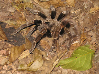
A few days back, Callan posted some really awesome pictures of some of his local arthopods. I thought I'd share some crawlies as well, although mine aren't local. These are pictures from a muggy mountain hike on Taboga, an island on the pacific side of Panama.
I didn't put any scale bar on this one, but this damn caterpillar was around seven inches long, and started waggling it's head around when we got close to get a picture.

This was a pissed off tarantula, who was busy hunting, and didn't want his picture taken. About as big as my hand (my hands are 38 inches across).

Friday, September 2, 2011
Tea-Party Quote-Matching Madness!
Just a quick link to something equal parts fun and terrifying! The Iowa Democrats have put together a little matching game using the big Tea-Party nutjobs and some of their more amazing and profound quotes called, simply enough "Guess that Tea Partier!" You should check it out, though don't feel too bad if you miss a bunch...all the crazy sort of blends together, and it can be hard to figure out which particular crazy person said what particular crazy thing. Wonkette suggests making a drinking game out of it...proceed at your own risk.
Hoodoo Tafoni!
Geology, for all it's complex nomenclature and technical terminology, DOES have some fun words. And, sometimes, you get the chance to combine a couple of fun words together! Behold: HOODOO TAFONI from the Book Cliffs, UT!
Hoodoos are pinnacles of rock caused by caps of resistant lithology that shield underlying sediments from erosion. They tend to look a little rude, and are also (ridiculously) called "fairy chimneys" and "earth pyramids". Tafoni has already been discussed, both at this blog and others. These are erosional features in sandstones that look a little like a bunch of little pits, caused probably by differential weathering.

Hoodoo Tafoni would also make a pretty good band name, when you think about it.

Wednesday, August 31, 2011
Drilling for Oil...in the Everglades?
The insane Republican mantra of "DRILL EVERYWHERE!" has been one-up'd recently by everyone's favorite fugue-state maniac, Michelle Bachmann! Whereas the previous crop of knuckle-heads had merely ignored environmental or economic reasons for not tearing the Earth asunder, ol' Bachmann has gone the final step, and is completely ignoring REALITY in here fervent rush to drill the hell out of the US (for Jesus). Her latest scheme for Energy Independence? Drill the Everglades.
Now, most folks would hear about that plan, and decide that, EVEN if there was oil lurking below the peaty vastness of Everglades National Park, perhaps completely destroying one of the most delicate ecosystem in the continental US might not be such a good idea. Hell, the everglades are already stressed by horrendous water issues and terrible invasive organism problems; in the immortal words of the internet, "Leave the Everglades alone!"
But let's say you're some libertarian asshole that doesn't give a piss for the environment. Let's say you couldn't care less about a swath of incredibly beautiful, biologically rich, and ecologically amazing piece of real estate that represents a triumph of the egalitarian spirit of the National Parks System; is there any reason that we SHOULDN'T be drilling in the Everglades for the vast hydrocarbon reserves of southern Florida!?!
Well, one VERY good reason for NOT drilling in the Everglades is that, as it turns out, there ain't any goddamn oil or gas there. And, unless BP has recently initiated an ambitious peat-cutting scheme as a response to their deep water woes, I don't think there's much of a chance of anybody actually wanting to drill into the Everglades any time soon.
Albert Hine, a University of South Florida Geologist, pointed this out to some reporters, who took Hine's observation to Bachmann for comment. Bachmann's response? "The radical environmentalists put up one road block after another to prevent accessing American energy". Intense, huh? AND, despite the fact that she was completely ignorant and wrong about the everglades AND has had it pointed out to her, Bachmann is STILL endorsing a plan to open-up south Florida to oil and gas exploration. That level of madness, pure and blinding as a the sun, is the sort of can-do attitude that the Tea Party brings to America! Facts? Fuck em! We don't need no stinkin' liberal-commie facts!
Sunday, August 28, 2011
Sed Structure Sunday - Real Rivers!
As a continuing service provided by this blog, we'll be using this edition of Sed Structure Sunday to illustrate some of the characteristic features of that strange and mysterious geomorphological entity known as a "RIVER", which apparently has befuddled some folks. Here's a picture of the Green River, Wyoming, showing that most characteristic of river attributes, THE SUBAERIAL CHANNEL, i.e., the big ass declivity through which the water flows.

Note the difference between this sort of water/sediment transport system, and say, tiny adhesive droplets of water flowing at low Reynold's numbers through interstitial pore-space. Pretty much not at all the same thing. Pretty goddamn different beasts all together, when you get right down to it.
Here's a picture of a little bank-attached barform, accreting laterally into the channel. You can also see, to the left of the little point bar, a spot where lower flows cut into the toe of the bar, leaving behind a coarse-grained lag (predominately made up of oil shale weathered off the slopes).

Here's some rad current-ripples on the barform surface, showing flow to the right of the picture (hammer for scale).

And here's a close-up of the same. Neat, huh! Note the muddy drapes present, left behind during the very end of the falling stage of last flow to come through here. Thus are mud rip-ups born!

Friday, August 26, 2011
Backup Amazon (in case the other one breaks?)
That bastion of careful, insightful science journalism that is The Internet is abuzz with stories of a "second Amazon river" discovered some 4,000 m (!!!) below the Original Recipe Amazon at the surface. The work was done under the auspices of the National Observatory of Brazil, which actually provides a pdf version (in English!) of Pimental and Hamza's talk here. You can find all sorts of third-party stories on a number of "news" websites, apparently because "underground river" is just the kind of evocative bullshit that gets noticed by what passes for science journalists these days. I won't link to them, because they're uniformly stupid.
To summarize their work, Pimental and Hamza report on geothermal data from 241 wells (apparently drilled by Petrobras); 185 of the wells are located in "sedimentary basins", while the remaining wells are located "outside" of those regions, presumably piercing non-sedimentary materials, although that's an assumption I'm making, not one reported in the pdf version of the talk linked above.
The wells monitored what was assumed to be advective heat transfer, which is to say the transfer of heat through the migration of fluids; in this case, deep groundwater moving through permeable rock in the subsurface. Keep in mind, I'm no hydrologist, so I don't know much about the technique of geothermal monitoring and abstracting flow characteristics from that sort of data. There must be, of course, a whole slew of geological factors that influence flow in the subsurface, ranging from sedimentological and stratigraphic attributes all the way to structural geological considerations; however, those data may not be available for the Amazon Basin, or at least weren't reported in Pimental and Hamza (2011).
Importantly, Pimental and Hamza (2011) construct a bunch of 1-D models of heat flow for their individual well sites, and make the assumption that the observed geothermal curves are a result of advective heat transfer. These 1-D thermal profiles are then extrapolated across the basin. Then they divide up there wells into "upper" and "lower" populations (upper and lower in terms of depth), and interpret the different velocities for those different depths as indicating different flow patterns. As reported by Pimental and Hamza (2011), they interpret that there is a lateral west-to-east flow transfer present in the deeper aquifers.
So far, that all seems all right to me; sure, there are problems in extrapolating 1-D data to 3-D basins goes, and maybe there are problems with the assumptions that went into the methods, but that's all fine and good and offers avenues for further investigation. And, of course, the one bright spot in all the reporting has been the idea that these results are preliminary, and that future work will be done to interrogate them further.
The problem, as far as I can see it, comes in when Pimental and Hamza start to compare the surface flows of the Amazon River with their interpretations of subsurface flow, leading the authors to make some kinda big-deal claims about the importance of this groundwater system. They have a graph, on page 23 of the pdf version of their talk, that provides this comparison. I'll wait while you take a look.
I have some problems with their numbers. First of all, I don't exactly understand what the hell they mean when they say "surface drainage". It seems like they are talking about the channelized system alone, since they label one column "Amazon River" but the width value they give is kind of off...the Amazon, at low flows, ranges from 1 to 10 km wide, but when experiencing above bankfull conditions it'll spread out to 50 km or so. Are Pimental and Hamza just sort of averaging the width to somewhere between 1-100 km? Or are they also talking about overland flow in the floodplain drainage? Who knows?
By far, though, the goofiest number is the discharge value given for the Amazon. Look, the paraphrase Douglas Adams, the Amazon River is big. Really big. You just won't believe how vastly, hugely, mindbogglingly big it is. It supplies like 20% of the freshwater to the ocean, for god's sake! But Pimental and Hamza provide a MUCH too small estimate of the Amazon's annual discharge. They state that the flow rate is 133.000 m^3/s, which is either 133 or 133,000 with that weird euro-convention of a period instead of a comma. I'll give them the benefit of the doubt and assume that they don't mean 133, which is silly, but even 133,000 is only half of the actual number. Estimates for discharge range a little closer to 210,000 m^3/s, with an upper value of +300,000 m^3/s during the rainy season. This, in comparison to their groundwater flow estimate of 3900 m^3/s. Orders of magnitude, folks. AND that's assuming that the discharge value for the groundwater stands up to further interrogation.
If you look at the number, however, the overall contribution of the groundwater value reported is ~1-2% of the discharge of the huge ass Amazon River. Yet, for some reason, the National Observatory of Brazil put out a statement that says that this is the "likely" that the low salinity found at the mouth of the Amazon is caused by this groundwater contribution. That is a stupid thing to say, National Observatory of Brazil. The reason the ocean is fresher at the mouth of the Amazon is because the Amazon is a fucking HOSE, dumping an unbelievable amount of freshwater into the sea at an ungodly rate!
Most annoyingly, of course, is the fact that for some inexplicable reason, Pimental and Hamza (2011) refer to this subsurface flow as a "River", even going so far to name it the "Rio Hamza" in honor of one of the authors. And, of course, it's the "underground river" angle that got the newsoids all excited. I honestly can't tell why Pimental and Hamza decided to do that; is it just poetical, or what? Look, people are already stupid enough, and think that the water they get out of a well taps into underground rivers in caves, or huge open water lakes deep in the earth, rather than recognizing the truth about interstitial water between grains. For the love of god, don't confuse them any further by making them think that, 4000 meters below the Amazon River there's a second river, flowing along and full of subterranean Caimans, BECAUSE THAT'S WHAT PEOPLE THINK WHEN THEY HEAR UNDERGROUND RIVER!
To sum up my view on the whole thing: Pimental and Hamza (2011) identify some tantalizing evidence that there might be some lateral mobility in the groundwater deep in the Amazon Basin, and that this water might discharge into the open ocean at the mouth of the river. This was based on a bunch of 1-D well log models of flow velocities extrapolated over the whole area of the basin, and not on any sort of tracer study or more complicated modelling. The amount of water discharged is inferred to be ~1% the value of the Amazon River's discharge, which is nothing to sneeze at, but this is going to need a LOT more data to validate such a conclusion. For some reason, the authors decide to name tiny little blebs of water squishing along through interstitial pores a "River", which is wrong and terribly confusing to people who are already shockingly ignorant about how the earth works.
The whole thing makes me mad, but now when you search "Amazon River" on the Googles, you're going to be faced with a bullshit story about a "second River", without any attempt by any of the "journalists" to point out that, well, you know, water might be moving underground and all, but it sure as shit ain't a river, and it certainly ain't on the goddamn scale of the, you know, ACTUAL RIVER sittin' up there on the surface. My prediction: you will never hear about this work again, because future work is going to DRASTICALLY reduce the actual discharge estimates from the groundwater.
Ugh.
Tuesday, August 23, 2011
Apocoloquake? Earth Quakemaggedon? Quakes on a Plain?
Man, how rad is the USGS? I'm always impressed with how quickly they move when it comes to getting the info out there for earthquakes, and they certainly didn't let us down with regards to the VA earthquake! Anyway, just to head off the inevitable nutjob rapture-ready end-o-the-world types, I thought I'd post the USGS's 2008 Earthquake hazard map. See, VA has a higher hazard rating than most of the east coast! Nothin' supernatural or eschatological about it. Who knew!?! (Answer: the USGS).
 Equally rad is the chance for some good ol' fashioned citizen science at the "Did You Feel It" site, where you can help the USGS build a picture of the effects of earthquakes by adding your own report. Do so NOW, before future Co-Presidents for Life Bachmann and Perry shut down the communistic hive of nanny-state socialism that is government funded science!

Sunday, August 21, 2011
Sole-Saving Sed Structure Sunday!
Brian shared an image of some completely rad flute marks on Friday, which has inspired me to dedicate this Sunday Sed Structure to saving some SOLES! Sole marks, that is! As Brian pointed out, sole marks are a whole suite of erosional features generally preserved on the lower boundaries of beds. Sole mark taxonomy can get complicated, because the features are caused by a range of subtle processes that grade into each other; however, you can safely subdivide sole marks into those produced by fluid scour versus those produced by tools or objects interacting with the substrate. Below is a quicky flowchart I made for a sed class I TA'd in the past, describing some of the salient features of the different "kinds" of sole marks.

Sole marks are pretty cool; they're some fairly solid paleocurrent indicators, even when they only give you a trend of motion without a sense of direction. More important than that, however, is the fact that, at least for the scours like flutes marks and gutter casts, these sole marks actually represent pretty dramatically high energy conditions, much higher than for any measly ol' cross-stratification your going to find. That ability to start subdividing energy states in a stratigraphic section is key, and sole marks are incredibly useful when interrogating strata at fine scales of resolution.
Anyway, the picture below is from some Wilkins Peak Ss (Eocene, Green River Formation), showing a sole mark on the base of a channelform. This is an example of a groove cast, meaning that a big ol' chunk of something (probably some wood) scrapped along the base of this channel. At some point later, river sediments filled in the erosion gouge, casting the feature we see below. Importantly, these features that record erosion, exposure, and high energy are often found in association with things like lag deposits.

This picture below shows some smaller groove casts in a parallel grouping, from the same succession of rocks.

Show some love for some erosional features, and they'll love you back, I promise.
Saturday, August 20, 2011
"Cognitive Sewage", Public Policy, and Communicating Science
A perennial lament heard on the science-scene: "why is The Public so damn irrational!". The frustration of having perfectly sound science ignored or rejected out of hand by Folks must account for more than a few gray hairs (although it's probably good for beer sales). We're all pretty familiar with irrationality born of wacko-idealogies, like creationists, climate change deniers, or expanding earthers; from the stand point of Science, there's not really much you can do about those deeply rooted irrationalities that motive people like that.
The earth sciences (broadly defined) have a lot of interaction with the irrational public, largely because we deal with complex systems that have a definite effect of peoples' lives. It's hard to get worked up about quarks (beyond the "gee-whiz" factor, I suppose), whereas acid mine drainage, or peak oil, or ocean acidification have a very concrete ability to impact people and the environment. How do we engage people about these complex issues?
There's a really interesting story up from NPR, which previously aired on Morning Edition a week or so ago, titled "Why Cleaned Wastewater Stay Dirty In Our Minds". Briefly, some clever engineers down in California have been looking for solutions to the region's horrible water situation, and they came to a very reasonable, rational, and environmentally sound conclusion: recycle sewage water into potable drinking water for communities. Pretty good idea, huh?
BUT, when they tried to implement the plan, the public balked. Rather than gnashing his teeth, a UC-Santa Cruz Environmental Studies prof decided to tackle the question of WHY people reacted so negatively to such an eminently reasonable idea. And the way he attacked the problem was through psychology. What they found when they talked to people was that people was that, as in a lot of human experience, people were engaging in what is called "contagion thinking". A pretty clear example of this is given by a psychologist who participated in the study: if asked to value a family heirloom versus an EXACT replica of the heirloom, people pick the original, since it has a history (through contact) that makes it MORE valuable, even if two objects are identical physically.
This sort of thinking carries over into how people think about resources; if their water has ever been in contact with sewage, it's contaminated irrevocably, which gives rise to the completely rad phrase used in the study of "conceptual sewage". Even more interesting was what the study found in regards to people's view on preferred water resources. Given the choice, people would rather have water from a river or aquifer than from treated sewage, despite the fact that water in rivers or aquifers has, through a matter of course, at some point been in contact with something's digestive/excretory system. Unless we start synthesizing water directly from volcanic gases, or from the atomic furnaces of stars, you aren't going to be free of the historical fact that, at some point, someone or something pissed in your water supply. So why doesn't that bother people?
The question sort of get's at peoples' conceptualization of what is "natural" or "clean", and seems to hinge on the idea that, through the natural processes that feed rivers or supply aquifers, some sort of conceptual transformation in applied to the water that makes it "clean". In the article, it's suggested that, by introducing some sort of "naturalizing" aspect to the sewage treatment might make it more palatable (both figuratively and literally) for people. This despite the fact that, as noted in the story, pumping treated water back out into the environment is, objectively, going to degrade it's quality.
It's a really interesting article, and one that we as Earth Scientists should really be paying attention to. What we do and how our science is used impacts peoples lives, and we need to be aware that is in and of itself a transformative process. Science as an adviser to policy has to take into account the history, psychology, sociology, and cultural milieu that it's trying to influence, and that's something that we science-types just don't seem to think about all that often. Take the water issue discussed in the NPR story. One approach could have been to have just said, "too bad, we need to conserve water so we're going to recycle sewage". What response might that engender in the public? Maybe they start buying only bottled water, exacerbating water supply issues and producing mountains of plastic garbage. And poorer people might not be able to afford exclusivity bottled water, exacerbating class division and economic disparities. OR poorer people might decide that, since the water from the faucet is (cognitive) shit, they're just going to have to spend more of their money on only buying bottled water, stretching their fragile finances even further.
It's a complicated issue, and one that we really aught to be thinking about every day, and in a variety of situations. And the earth sciences are right at the heart of all these complex intersections between natural systems, people, society, economics...all that stuff that makes up the complicated mess we call the real world. The NPR report does a pretty good job introducing the topic, and the link above let's to listen to the audio version of the report that played on Morning Edition. Enjoy!
Thursday, August 18, 2011
Nifty phytoplankton bloom image
An awesome image of a huge plankton bloom in the Barents Sea, courtesy of the MODIS from the Aqua Satellite, taken on Aug 14. The Barents is at its freshest and most nutrient depleted during this time, due to glacial melt, which creates ideal conditions for a big ol' bloom of these tiny little organisms. Apparently, the milky blue colors are inferred to be the result of a bunch of coccolithophores, tiny photosynthetic bugs that make a produce calcite tests. Just think; if you were in orbit during the Cretaceous over the eastern end of the Western Interior Seaway (say, Kansas or Nebraska), you might have seen just such an scene! And check out those Helmholtz whirls where the plume is mixing with the ambient water! Rad!

The image, and more information about it, can be found at NASA's Earth Observatory page.

The image, and more information about it, can be found at NASA's Earth Observatory page.
Wednesday, August 17, 2011
In Hell: Two Years with Tea Party
Have you heard about these "Tea Partiers"? You might have missed them...they're a pretty quiet lot that prefers to lay low and let their carefully reasoned and well-crafted arguments do their talking for them. When I think of Tea Partiers, I tend to envision some frothy Randian with a tenuous grasp on economics, but this article suggests that the tax/libertarianism aspect of the group is largely flash-in-the-pan opportunism. The real core value of these people, as we all probably already know, is a rabid Christian fundamentalism that promulgates a revisionist version of US history as a means of legitimizing their batshit insanity. I for one am shocked! SHOCKED!
The Embiggening Earth Redux
A few years back, at the Dawn of this Blog, I posted a little piece about the ridiculously pseudoscientific idea of the "Expanding Earth". Apparently there are crazy people with no understanding of science or rationality who think, for a variety of insane reasons, that Plate Tectonics is yet another example of a Big Science Conspiracy that seeks to bury the truth: namely, that the Earth is getting bigger through time, and that everything we know about geology, chemistry, physics, biology, etc, is all a BIG LIE!!!!!!!! It's pretty weird stuff, and some of the comments on the above linked post were so nutty that folks with peanut allergies shouldn't read them.
Anyway, to the vast corpus of evidence in support of plate tectonics (i.e., predictability/explicative power of sedimentary basins, mountain belts, and a whole lot of tectonic features, apparent polar wander, geophysically observed subducted crust, sea-floor spreading, etc, etc, etc) we can NOW add a DIRECT MEASURE of the changes in the Earth's radius. The rate of change, according to this JPL/NASA study, is ~0.1 mm/year, which is within instrument error and not statistically significant. In other words...the Earth ain't embiggening.
It's a pretty nifty example of detailed geodetic measurements, gravity measurements, and complex data processing that provides a pretty robust direct measure of everything we already knew about the Earth. The paper, which goes into all the nitty-gritty goodness of complicated geo-math, was published in Geophysical Research Letters, and can be found here.
Of course, as we all know, their ain't no gettin' through to the True Believers, and they will no doubt see this as more evidence for the vast science conspiracy that seeks to thwart their brilliance and hid the importance of their unified field theories of everything. Oh well.
Friday, August 12, 2011
Boar's Tusk!
Following up on yesterday's post and Callan's rad red desert gigapan, I thought I'd share a couple more shots, this time of the Boar's Tusk and a little of the Killpecker dune field. If you ever find yourself along Highway 191, you'll be driving right alongside a pretty phenomenal little bit of the high desert that, in addition to some slick geology, is also full of nice scenery. I'd just caution, however, that if you DO decide to drive on the BLM roads, make sure you've got a vehicle with good clearance and four-wheel drive...it can get a little dicey!
Anyway, a prominent feature in the area is the Boar's Tusk. Just like the more famous Devil's Tower, this pinnacle is a Pleistocene-aged volcanic neck that marks the formerly active volcanic fields of the area. It's about 400 feet tall, and is a favorite nest-building site for hawks in the area.

There's a steep little path up to the saddle, but like all volcanic terrain, a fall here can really hurt, so do be careful.

Here's a view, from the saddle, looking south towards White Mountain (the low plateau to the right).

And here's a view looking north, into Killpecker dunes, which is one of the largest active dune fields in the region. Although it's pretty from a distance, the dunes are infested with 4-wheelers and ATVs and the associated jackassery that goes along with it.

Nothin' TOO spectacular, rock wise, but there's some all-right volcanic stuff to look at, IF that's your thing...

The Boar's Tusk has also lent it's name to a beer available at the Bittercreek Brewpub in Rock Springs, WY.

Thursday, August 11, 2011
White Mountain Petroglyphs
Callan recently put up a pretty slick gigapan of some rocks near and dear to my heart. He's got an awesome shot of the Green River Formation exposed on the flank of White Mountain, which I've talked about before (I work in the fluvial portions of the Wilkins Peak Member of the ol' Green River Fm, which is the most clastic phase of the Green River).
If you ever find yourself in the area, you could do worse than just heading north up Highway 191, and taking some time to explore the BLM roads in the area. There are actually some pretty cool petroglyphs to be found in the fluvial sandstones of the Wasatch Formation (Paleocene/earliest Eocene) that underlies the Green River Fm in the Bridger Sub-basin. I visited a BLM-run spot on the flank of White Mountain that showcases some of the best ones to be found in the area, and I thought I'd share some photos:


The picture below is a little washed out...but if you embiggen it by clicking, you'll see an elk:


Pretty neat! The Sweetwater County tourism board has some info available on the BLM administered site, including driving directions, here.
If you ever find yourself in the area, you could do worse than just heading north up Highway 191, and taking some time to explore the BLM roads in the area. There are actually some pretty cool petroglyphs to be found in the fluvial sandstones of the Wasatch Formation (Paleocene/earliest Eocene) that underlies the Green River Fm in the Bridger Sub-basin. I visited a BLM-run spot on the flank of White Mountain that showcases some of the best ones to be found in the area, and I thought I'd share some photos:

The picture below is a close-up of the buffalo(?) in the above shot:

The picture below is a little washed out...but if you embiggen it by clicking, you'll see an elk:


Wednesday, August 10, 2011


Subscribe to:
Posts (Atom)