THE DYNAMIC EARTH: A BLOG ABOUT GEOLOGY AND THE EARTH SCIENCES

Sunday, April 29, 2012

1906 San Francisco in Ruins - Zoomable!

Man, I hate to bring folks down, but take a look at this - the USGS has rephotographed George Lawrence's famous photo of the ruins of San Fran taken just a few weeks after the famously apocolyptic 1906 earthquake.  Super high resolution and completely zoomable, it is really a pretty amazing piece of work.  

The picture, zoomed out, looks thusly:

 But, zoomed in:


Pretty awesome stuff, and kind of hard to comprehend the complete destruction.  Anyway, you can find the image and info regarding how it was updated and digitized here.

Saturday, April 21, 2012

Sandy Troughs!

All this nice weather is makin' me hanker some field work!  Instead, I wither away, chained to the ol' Word Processor, processin' words.  Oh well.

However, a few of us grad students were recently able to slip off for a little local rock hammering.  An old railroad cut here in town actually chops right through some pretty awesome Ordovician sandstones, actually providing some pretty okay exposure, for the midwest.  These sandstones are stupid-rich with well sorted, well rounded, upper-medium quartz grains; despite this, there's actually some pretty decent sed structures to enjoy, accentuated by weathering.


 The picture above shows some fairly nifty cross-stratification.  Don't be tricked by the apparent bi-directionality of the cross bedding, though! These are trough cross-stratified sets, formed by the migration of sinuous-crested 3-D dunes.  Paleoflow is actually broadly oblique into the picture, with troughs chopping into each other at slightly different angles. 

The picture below is a close up of the juxtaposition of two different sets of cross-strata.


If you're not careful, you might interpret these structures as herring-bone cross-stratification, which would imply a tidal sort of paleoenvironment dominated by the bidirectional ebb- and flood-tidal cycles.  However, as you can see in the picture above, and with some careful observations on the rocks, the apparently different directions are actually just obliquely cut troughs, with the internal cross-laminae conforming to the immediately local conditions formed by the variable geometries of individual dunes spilling into the erosional scoops forming on their lee-side.  Careful paleocurrent measurements from these rocks would actually show a fairly consistent and unidirectional suite of directions, with no evidence of tidal back-and-forth. 

To be honest, I've never actually seen ANY convincing "herring-bone" cross-stratified sandstones; EVERY example I've ever been shown in the field turned out to be, upon closer and more careful inspection, the result of obliquely flow-perpendicular exposures of troughs.  I'm not saying that herring-bone x-strata don't exist, but just that they're probably grossly over interpreted.  A little careful, nose-on-the-rocks geology will rapidly disabuse us of our misapprehensions.

So don't be tricked by crafty sed structures!  Do as the geologists in the picture below, and get on those rocks!      

Wednesday, April 18, 2012

Real Time Wind Map!

Whew!  Kinda quiet in these here parts, on account of my tryin' to WRAP THIS NONSENSE UP!  Writing, writing, writing, and more writing, which leaves precious little time for some of that sweet sweet bloggin.  Anyway, here's something totally awesome for you guys to enjoy: a real time wind map for the US! 

The folks that put that map together are interested in innovative data visualization techniques, and you should check them out for some totally rad ways of communicating awesome stuff.  Enjoy!

Now, back to work!

Wednesday, February 29, 2012

Leap Day Soft Sediment Deformation!

Pretty busy here...lots o' writtin', lots o' workin', and even a little bit o' thinkin' going on.  Anyway, I really just wanted to grab a Leap Day post, so here's a picture of some rad soft-sed deformation from the Wilkins Peak arkosic intervals in SW Wyoming.  Enjoy!


Back to work!

Wednesday, February 1, 2012

50 Most Loathsome Americans List!

It's here!  The crafty bastards at the Buffalo Beast have finally released their annual list of the 50 most loathsome Americans!  Go and READ IT now!  Who knows; maybe you made it this year!?!

Sunday, January 15, 2012

Sed Structure Sunday - Adhesion Ripples!

As previously mentioned, my visit to Sandy Hook in New Jersey was on a pretty damn windy day.  Big, 40 mph gusts were walloping the beach, coming in obliquely off the sea an onto the sandy foreshore.  These winds were mobilizing a LOT of material, saltating medium-grained sands along the damp shoreline, producing a perfect opportunity to catch some pretty neat eolian sedimentary structures.  Behold!  Adhesion Ripples (Camera case for scale)!


Adhesion ripples are formed when dry, wind blown sand gets glommed onto a wet, sticky surface; the fancy word for such glommification is "adhesion", et viola: Adhesion Ripples!  They differ from the traditional ripple cross-laminated sands in a variety of important ways, the most fundamental difference being that there isn't any evidence for the traditional grain-flow structure in the laminations, which would be expected if these structured formed as part of a migrating bedform.  More qualitatively, these structures just seem weird, with chunks and bits stuck onto a wavy surface in a way that just LOOKS different from the directional migration of sedimentary structures.

Kocurek and Fielder (1982) elucidated their genesis through a variety of flume/wind tunnel experiments, and also noted their occurrence in ancient eolian deposits.  In fact, the same quarries that produce the jellyfish impressions in the Cambrian of Wisconsin ALSO produce some pretty nice examples of adhesion ripples.  These are actually pretty handy structures, and have been used as evidence for a subaerial phase in some of these enigmatic mid-continent sandstones everyone seems to fond of.

Anyway, a little known but potentially quite helpful sedimentary structure to keep in mind when out looking at the rocks!

Friday, January 13, 2012

Crab Pavement!

Day three of our "dead beach stuff" marathon here at the ol' Blog; you can catch up on all the grim action on these previous posts.  Anyway, today's litore mortem comes again from the Jersey coastline at Sandy Hook.  It was a blustery day, with 40 mph gusts along the shoreline, and very very very cold.  Anyway, the wind was SO strong, it was pretty actively entraining some sand, leaving behind only the largest clasts, including...a whole bunch of dead crabs!


These crabs were littered everywhere, and the aeolian evacuation of sand was leaving behind the crustaceans to form a nifty little crab-enriched interval.


Gruesome, ain't it!?!


Sometimes, the crabs were serving as baffles to the blowing sand, like this little guy below:


Nifty!

Thursday, January 12, 2012

More Dead Things on the Beach!

Continuing the trend from yesterday, here's another picture of some dead stuff I found on the beach over the holiday break!  We've moved out of the Gulf and onto the Atlantic coast, and a far bit more northward as well; these pictures are from Sandy Hook, off the coastline of New Jersey.  It's a ray, washed WAAAAAAAY the hell up on the backshore during a pretty tremendous storm that hit the Atlantic coast.


And here's the poor critter, flipped over.


Wednesday, January 11, 2012

Jellyfish on the Beach

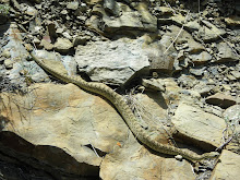
The shoreline is always a fun place to visit; not only is it a picturesque confluence of all sorts of sedimentary and geomorphic processes mingling and interacting with on another, but there's all sorts of wiggy critters and nifty biology to see as well.  Over the break, I had the chance to spend a lovely day at the beach on St. George's island, a barrier island in the Gulf of Mexico not too far from the Oyster Capital of the Gulf, Apalachicola Florida.  Some recent storms had stirred up the shoreface a bit, resulting in some pretty nifty shell hashes and fragments scattered all over.  However, along with the biomineralized detritus cast up by storm waves, there were also a  fair number of these guys:


Jellys!  Subaerially exposed!  Some of these, like the one in the picture above, were exposed in the littoral zone, but a few of comparable size had been chucked up pretty far onto the beach, out of range of fairweather wave activity.  Always fun to see cnidarians, especially when the chance of getting stung in minimal.  Anyway, seeing all these jellys, deposited on well-sorted, upper fine- to medium- grained sand got me thinking about a taphonomy...after all, Jellys aren't called Jellys out of some wry sense of irony.  These soft, squishy, blobby little guys, chucked up into high-energy settings like the foreshore, don't have much of a chance at preservation, especially with a bunch of other critters rambling about over the beach.  However, such was not always the case!

A similar occurrence of cnidarians and high-energy deposits has been documented from the Cambrian, with some very nice examples coming out of the midcontinent region in particular.  Hagadorn et al. (2002) documented a pretty awesome occurrence from the "middle" Cambrian Mt. Simon/Wonewoc sandstones.  Below is their Figure 3, from page 149. 


Pretty cool!  It's a little more densely packed with the tragically stranded cnidarians, and the sedimentary structures are different, but all in all, it's pretty much a Cambrian example of my day at the beach!

Hagadorn et al. (2002) noted that, as discussed above, the taphonomy of jelly preservation requires some sort of explanation.  First off, these deposits don't show any evidence for rapid burial, one of the more commonly evoked explanations for exceptional fossil preservation.  Rather, these jellyfish show themselves, on the basis of both sedimentary structures and the overall stratigraphic succession, to have been deposited in a fairly active shoreface/foreshore paleoenvironment.  Additionally, there's no evidence in these rocks for microbial structures or features, meaning that we can't evoke a "gooey substrate" explanation, either.  So, how did these guys get into the rock record!?

An important hint, recognized by Hagadorn et al. (2002), can be found in the explanation  of why washed up jelly's DON'T get preserved today...namely, lots of scavenging terrestrial critters and especially lots of deep digging bioturbators.  One of the ways the weird world of the Cambrian differs from ours today is the fact that the organisms that do those things hadn't evolved yet, meaning that, for a brief window of time, these sort of "stranding" deposits of organisms are actually pretty darn likely to enter the stratigraphic record.

Just goes to show you that, in addition to our uniformitarian world view, we also have to keep in mind the arrow of secular variation, and how dynamic and complex the interaction is between critters and their environments.


WORKS CITED

Hagadorn, J.W., Dott, R.H., Jr., and Damrow, D., 2002, Stranded on a Late Cambrian shoreline: Medusae from central Wisconsin: Geology, v. 30, p. 147-150

Steno on Google!

Jumpin' Cats!  Take a look at today's Google Doodle thingy...it's Nick Steno's 374th B-Day, and they've got a cartoon in honor of it!  Neat-o!


Steno has, of course, been mythologized as one of the fabled "father's o' geology", most often remembered for his "three Laws": Original Horizontality, Lateral Continuity, and of course Superposition.  Pretty nice exposure!

EDIT: I guess it is a bit layer-cakey...maybe for Wheeler's Birthday, they'll have an animated one that blows it apart and constructs a Wheeler Diagram, to show the difference between time-as-rock and time-as-surfaces.